The Face an Hour Before Sunset
On 25 July 1976, 64 minutes before sunset at Cydonia, Viking 1 photographed a hill that looked like a face; in 1988 a shape-from-shading study put it at 412.5 ± 17.5 m and argued its features would persist under other lights and views. This page decodes both original Viking frames and relights the HiRISE team’s 2025 terrain model of the same hill under the same sun. The render matches the photograph with a correlation of 0.970, the hill stands 356 to 363 m above its plain, and raised to the 1988 height its rendered shadow grows 4.1 pixels longer, further from the one Viking recorded.
Move the sun over the true hill
Cydonia, Mars, 25 July 1976. The hill in the 2025 terrain model, under the sun of that day.
Loading the Viking frames and the terrain model, about 2 MB, and decoding them in your browser…
The picture on the right is the photograph. The middle picture is computed: the measured hill, lit by the sun the page calculates for the time you choose, seen at the Viking camera’s angle and blurred to its pixels. The correlation in the readout compares the two.
Relit under the Viking sun, the HiRISE team’s 2025 terrain model matches frame 35A72 with a correlation of 0.970 and stands 362.0 m above its plain; raised to the 1988 model’s 412.5 m, its rendered shadow grows 4.1 pixels longer and moves further from the frame’s.
Everything below is computed in your browser from files this page ships: the two Viking frames exactly as NASA’s Planetary Data System archives them, and the HiRISE team’s terrain model of the hill, averaged from 2 m to 8 m posts. Numbers taken from a publication are marked and cited where they appear. Every other number is the page’s own, and the check at the bottom recomputes the page against itself while you read it.
I · the claim, at full strength
Two frames, one face, and a 3-D model of it
On 25 July 1976 the Viking 1 orbiter, photographing possible landing sites for Viking 2, took frame 35A72 of a region of mesas and knobs in Cydonia. One hill in it looked like a human face, and NASA’s caption of 31 July said so and said why:
The huge rock formation in the center, which resembles a human head, is formed by shadows giving the illusion of eyes, nose and mouth. The feature is 1.5 kilometers (one mile) across, with the sun angle at approximately 20 degrees.
NASA/JPL-Caltech, The “Face on Mars”, caption of 31 July 1976
Some years later DiPietro and Molenaar, engineers at NASA’s Goddard Space Flight Center, found the same hill in a second frame, 70A13, taken on 30 August 1976 under a higher sun. In 1988 Mark J. Carlotto, then at The Analytic Sciences Corporation, published a quantitative case that the face was more than a lighting effect. He rebuilt the hill in three dimensions from each frame by shape from shading, and wrote in the abstract:
Image enhancements of the face show it to be a bisymmetrical object having two eyes, a nose, and a mouth; fine structure in the mouth suggesting teeth are apparent in the enhanced imagery as well as crossed symmetrical lines on the forehead. Facial features are also evident in the underlying 3-D surface which was reconstructed using a single image shape-from-shading technique. Synthetic images derived from the 3-D model by computer graphics techniques suggest that the impression of facial features evident in the original Viking imagery are not a transient phenomenon; i.e., they persist over a wide range of illumination and viewing conditions.
Mark J. Carlotto, “Digital imagery analysis of unusual Martian surface features”, Applied Optics 27(10), 1926–1933, 15 May 1988, doi:10.1364/AO.27.001926
The page tests none of the claims in the first of those sentences: they are readings of enhanced Viking pixels, and the page scores no likeness to anything. It tests the 3-D surface and the relighting. A corrected and revised version of the paper, hosted by the Society for Planetary SETI Research, concludes: “It is the author’s belief that although the Viking data are not of sufficient resolution to permit the identification of possible mechanisms of origin for these objects, the results to date suggest that they may not be natural.” Whether the 1988 print carries the same wording could not be checked here: its full text is behind a paywall. The quotations below marked “corrected version” come from that copy.
The two frames, decoded here
The page reads each frame in its archived form, a Huffman code of the differences between neighbouring pixels, and decodes it in your browser. The label of each file carries a checksum, the sum of all 1,271,424 of its pixel values; the page adds up what it decoded and compares. Each frame is shown as recorded and after a 3 by 3 median filter, which removes the transmission errors the 1976 caption calls “bit errors”. Both are turned so that north is up, using the north direction printed on the frames’ ancillary labels.
The decoded pixel sum of 35A72 is 101,666,114, which equals the checksum in its label; for 70A13 it is 109,472,420, which equals its label’s.
This is Carlotto’s strongest point, and it is right. The same features sit in two frames taken 36 days apart under different suns, so they are not noise: “These features cannot be dismissed as noise in the imagery or artifacts of the processing since they appear in both images” (corrected version). Section II measures how right: the true hill, relit, matches each frame closely.
The 1988 numbers, as printed
| Table I, as printed | 35A72 | 70A13 |
|---|---|---|
| Sun azimuth (NORAZ–SUNAZ) | 294.28° | 277.04° |
| Sun zenith angle (INA) | 79.93° | 62.59° |
| Spacecraft azimuth (NORAZ–S/CAZ) | 169.05° | 139.54° |
| Spacecraft zenith angle (EMA) | 10.58° | 12.42° |
| Ground resolution (SCM) | 51.73 m/pixel | 48.13 m/pixel |
| Spacecraft range (RANGE) | 1873 km | 1725 km |
| Table II, as printed | 35A72 | 70A13 | Combined, as printed | the page’s arithmetic |
|---|---|---|---|---|
| Peak height | 430 m | 395 m | 412.5 ± 17.5 (4.2%) | 412.5 ± 17.5 (4.2%) |
| Length | 2.62 km | 2.46 km | 2.54 ± 0.08 (3.1%) | 2.54 ± 0.08 (3.1%) |
| Width | 2.06 km | 2.03 km | 2.045 ± 0.015 (0.7%) | 2.045 ± 0.015 (0.7%) |
| Maximum slope | 44.83° | 33.18° | 39.01 ± 5.82 (15%) | 39.005 ± 5.825 (14.93%) |
The Combined column is the mean of the two frames, plus or minus half their difference, with that half-difference as a percentage of the mean. The page redoes it and 4 of 4 rows agree with the print to its last digit. The slope row is exactly half-way twice, 39.005 and 5.825, and the print rounds one up and one down; both are within half a unit of the printed digits. The headline of the claim is its first row: a peak height of 412.5 ± 17.5 m.
The height from the shadow, rerun on the frame
The 1988 heights come from shape from shading, and the paper checked them with a simpler measurement anybody can repeat: “By measuring the lengths of the shadows in 35A72 and 70A13, the peak height of the Face was found to be approximately 400 meters using the values of the zenith angle given in the Science Data Block” (corrected version). A shadow of length L pixels at s metres per pixel, cast by a sun e degrees above the horizon, stands for a height of L × s × tan e. The page measures the shadow of the peak in the decoded frame along the direction away from the sun, 114.28° east of north, and ends it where the brightness climbs back past a threshold set midway between the shadow’s own level and flat ground.
The 1988 shadow method, on the 1988 frame
Midway, the shadow of the peak in 35A72 is 39.5 pixels long. At Table I’s 51.73 m per pixel and 10.07° sun that is 363 m, inside the 350 to 450 m that “approximately 400” covers when printed to one significant figure.
Midway, at Table I’s scale, measured from where the shadow starts rather than from the peak, it is 39.0 pixels and 358 m. A check that the band can fail: with the 1976 caption’s “approximately 20 degrees” in place of Table I’s sun, the same shadow stands for 744 m.
So the 1988 shadow arithmetic, rerun on the 1988 frame with the 1988 inputs, lands at 363 m: inside “approximately 400” printed to one significant figure, and below the 1988 model’s 395 to 430 m. It lands there on Table I’s 51.73 m per pixel, which is 8% larger than the scale the terrain fit in section II finds for this part of the frame. Both of the method’s choices move it. The frame’s shadow does not end in a sharp edge: its far end brightens gradually, so where it “ends” is a choice. A quarter of the way from shadow to flat ground it is 30.1 pixels long, midway 39.5, three quarters 41.7. And the ground scale is a choice: Table I prints 51.73 m per pixel; the ancillary label MSSS published prints 46; section II fits it on the terrain at 47.9 m. At midway those give 363 m, 323 m and 336 m. The closest the frame comes to “approximately 400” is 383 m, with Table I’s scale and the late threshold.
The page does not recompute the shape-from-shading heights of 430 and 395 m. The paper describes its method but does not print the weights that balanced its terms, and a reimplementation would be the page’s own algorithm, with a height the page chose. The paper does say one thing that matters for reading its table: its algorithm “forces the reconstructed surface to follow the grazing rays of the sun in shadowed areas. This provides an implicit boundary condition that in turn forces the lengths of shadows to agree with the heights of the objects casting the shadows” (corrected version). The shape-from-shading heights and the shadow height are therefore not two independent measurements.
II · the deciding control
The same hill, measured
What decided the question in the record were new pictures. On 5 April 1998 the Mars Orbiter Camera on Mars Global Surveyor imaged the hill at 4.3 m per pixel under a “morning” sun 25° up; on 8 April 2001 it imaged it again at about 2 m per pixel; on 5 April 2007 HiRISE, on the Mars Reconnaissance Orbiter, imaged it at 29.9 cm per pixel with the sun about 17° up. In the record, these pictures decided the question.
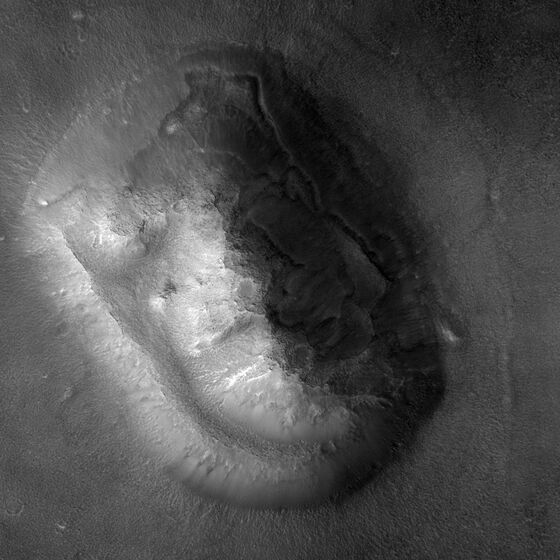
The control this page runs is newer. In 2023 HiRISE photographed the hill twice from different angles (ESP_080535_2210 on 1 October and ESP_080970_2210 on 4 November), and the HiRISE team turned the pair into a terrain model with a height every 2 m, tied to the laser altimetry of Mars Global Surveyor (product DTEED_080970_2210_080535_2210_A01, produced by Alfred McEwen and Kris Amanda Akers). Its README’s accuracy note gives a total RMS of 0.63802 pixels; RMS figures of 12.955 m in x, 1.7041 m in y and 0.5458 m in z, with a total of 7.5639 m; and a mean difference from the laser altimetry of −0.342 m with a standard deviation of 7.033 m. It does not say how each was measured; the heights this page reads are differences within the model over a few kilometres. On it the page measures what the 1988 table measured.
The terrain model against Table II
| measurement | Table II, combined | the terrain model, live |
|---|---|---|
| Peak height | 412.5 ± 17.5 m | |
| Length by width | 2.54 by 2.045 km | |
| Maximum slope | 39.01° (44.83° and 33.18°) |
The peak stands 362.0 m above a plane fitted to the low-slope plain 1.6 to 2.5 km from it.
Wherever the base is put, the hill stands 355.8 to 363.2 m above it: 355.8 m above the ground 1.5 km out, 361.2 m at 2 km, 363.2 m at 2.5 km, 362.0 m above the fitted plain and 362.6 m above the ground where its 35A72 shadow ends. That is below the 1988 range of 395 to 430 m at every choice. The length and width depend on where the hill is said to begin, which the 1988 paper does not print: at 20 m above the plain the outline is 3.04 by 2.31 km, at 50 m 2.53 by 1.89 km, at 100 m 2.25 by 1.61 km; at 10 m it merges with the swell the hill stands on and runs off the terrain model, so the page refuses to read it. The maximum slope depends on the cell it is measured over: 33.5° with the terrain averaged into 48 m cells, close to the Viking pixels and to 70A13’s 33.18°, and 53.4° over 8 m cells. The page refuses cells smaller than its 8.0 m posts; the slider’s first stop, half a post, shows the refusal.
Does the true hill make the Viking pictures?
This is the test of the whole method, and of the page’s own conventions. The page lights the terrain with the sun of Table I, casts every shadow, looks at it from the camera’s direction (10.58° from overhead, from azimuth 169.05°), averages it into square pixels and blurs it, then slides, turns and scales that picture over the frame until the two agree best. The scale is fitted only where the render is sunlit, so that it follows the outline of the lit hill and not the length of the shadow, which depends on the height the page wants to test.
The render matches 35A72 with a correlation of 0.970 and 70A13 with 0.975.
The fit finds north in 35A72 at 155.1° from the frame’s sample axis, where the MSSS ancillary label prints 154°, and in 70A13 at 171.0°, where that label prints 170°; it finds the ground scale at 47.9 m and 45.1 m per pixel, and the camera’s blur at 1.5 pixels. The Viking pictures are faithful pictures of this hill under that sun.
The same test catches the error that makes a face anyway. The sun’s direction in a Viking frame is printed in the frame’s own coordinates (SUN AZ 88° for 35A72) and has to be turned into a compass bearing by subtracting the frame’s north (154°), which gives the 294° of Table I. Light the hill from 88° as if it were a bearing, and even after the page refits the frame’s position and scale to the wrong render the best correlation is 0.44. Six such misreadings, including the four suns a pilot rendered while this page was being prospected, never reach above 0.65. That pilot reported that each of its four renders showed “a recognizable face-like mesa in visual inspection”, which is worth remembering: four renders lit from directions this frame rules out were each read, by eye, as a face. The page records that reading and scores no likeness itself. A sun due west gives 0.884 and north-west 0.857; the frame turned into its mirror image, 0.62.
The sun, from the clock
Table I’s sun came from the Viking science data. The page computes its own, independently, from the time in each frame’s label and the Mars24 algorithm of Allison and McEwen (2000), which it checks against NASA’s published worked example (for 6 January 2000 it gives Ls 277.18759°, equation of time −5.18775°, subsolar longitude 174.72600° and declination −25.22824°, where NASA prints 277.18758, −5.18774, 174.72600 and −25.22825). At 15:25:14 UTC on 25 July 1976 it puts the sun at 294.48° and 10.22° up, within 0.20° and 0.15° of Table I; the local true solar time was 18:34, and the sun set at the hill at 16:29 UTC, 64 minutes after the picture. For 70A13 it gives 277.04° and 27.73°, within 0.00° and 0.32°. The 1976 caption’s “approximately 20 degrees” is not the sun of this frame; rendered at 20° the hill still correlates 0.925 with the frame, because correlation is a blunt judge of the sun’s height, but it casts a shadow half as long.
Put the sun anywhere
Set a sun to see the hill under it.
The page refuses three things here and says why: a picture finer than the terrain’s posts, a date outside the Viking orbiter years it checked its sun against, and a shadow length when the peak’s shadow would leave the terrain model, which along the 35A72 sun’s line happens below 5.4°.
III · the control on the control
Plant the claimed hill and look again
A measurement that could not have seen a 412.5 m hill proves nothing about one. So the page builds that hill: it scales the relief of the terrain model above its fitted plain by the factor that brings the peak to the claimed height (1.139), inside the hill’s outline and tapering to nothing at its foot, and leaves the plain untouched. Then it runs the same functions that produced the numbers above on the doctored copy.
The claimed height, planted in the terrain
Raised to 412.5 m, the doctored terrain measures 412.6 m and casts a shadow 46.0 pixels long, against 39.5 in the frame.
The terrain’s own measurement recovers the planted height: 412.6 m for 412.5, 395.0 m for the claim’s lower edge of 395, 243.7 m for 800 feet. So the terrain model would have shown a 412.5 m hill had there been one. The harder question is whether the 1976 frame could tell. Rendered under the 35A72 sun at the fitted scale and blur, the planted hill casts a shadow of 46.0 pixels where the frame shows 39.5, a difference of 6.5 pixels. Not all of that is the planting: the render of the hill as measured is already 2.4 pixels longer than the frame’s shadow. Render against render, raising the hill to 412.5 m lengthens its shadow by 4.1 pixels midway, and by 4.1 to 4.2 at every threshold, always away from the frame’s.
The page decides with a rule it states here. A planted height is ruled out when its shadow differs from the frame’s by at least twice the combined uncertainty, which has three terms: the scale fit (47.1 to 48.6 m per pixel, worth 0.7 pixels on the planted shadow midway), one pixel for where the threshold falls, and the whole mismatch between the frame and the render of the hill as measured, because the page cannot explain that mismatch and will not assume it away. Midway the combined uncertainty is 2.7 pixels. The same rule applied to the hill as measured decides at no threshold, as it must.
| shadow ends | frame | as measured | 395 m | 412.5 m | 800 ft |
|---|---|---|---|---|---|
| at ¼ | 30.1 | 40.7 | 43.4 | 44.8 | 28.2 |
| midway | 39.5 | 41.9 | 44.6 | 46.0 | 29.8 |
| at ¾ | 41.7 | 42.8 | 45.6 | 47.0 | 31.8 |
| shadow ends | as measured | 395 m | 412.5 m | 800 ft |
|---|---|---|---|---|
| at ¼ | 10.6 against 21.3: cannot decide | 13.3 against 21.4: cannot decide | 14.8 against 21.4: cannot decide | 1.8 against 21.3: cannot decide |
| midway | 2.4 against 5.3: cannot decide | 5.1 against 5.4: cannot decide | 6.5 against 5.4: decides | 9.8 against 5.3: decides |
| at ¾ | 1.1 against 3.3: cannot decide | 3.9 against 3.4: decides | 5.3 against 3.4: decides | 9.9 against 3.2: decides |
By this rule the frame’s shadow rules out the 1988 height at 2 of 3 thresholds, midway and at three quarters; at a quarter, where the render fits the frame worst, it cannot decide. The claim’s own lower edge, 395 m, is ruled out only at three quarters. The 800-foot hill is ruled out midway and at three quarters; at a quarter the frame’s shadow is about as short as the 800-foot hill’s render. Render against render, the 800-foot hill’s shadow is 11.0 to 12.4 pixels shorter than the render of the hill as measured, at every threshold; what stops the rule at a quarter is the frame’s own shortfall there, which the page cannot explain.
That mismatch is the one thing that does not fit. The rendered shadow of the terrain as measured ends sharply, and the frame’s does not. At three quarters of the way to flat ground the two differ by 1.1 pixels; midway by 2.4; a quarter of the way the frame’s is 10.6 pixels short, because something lights the far end of the real shadow that the page’s render leaves out. The page does not model the sky’s light or the camera’s response and cannot say which it is. The same sun from Mars24 instead of Table I shortens the rendered shadow to 41.4 pixels; the switch in the panel above shows it. As a check on the 1988 arithmetic itself, the rendered shadow of the hill as measured, turned into metres at the fitted scale and Table I’s sun, gives 356 m for a hill the terrain puts at 362.0 m.
This is grade A of the wave’s power test: the claimed effect, at its claimed size, planted into the control’s own data and run through the unmodified functions. It covers the claim’s printed numbers. It does not score how much the hill looks like a face, because nobody has printed such a score and the page will not invent one.
Why 70A13 gives no shadow to measure
The 1988 paper measured shadows in both frames. The page refuses to measure the peak’s shadow in 70A13, and the terrain says why. Under that frame’s sun, 27.4° up from the west, a ray grazing the peak falls 156 m in the first 300 m, while the ground east of the peak falls only 78 m. The peak casts no shadow of its own along that line; the dark ground there in 70A13 is mostly the hill’s own dimly lit flank, with a few small shadows of local bumps, and the frame cannot separate it from a shadow. So the page reproduces the shadow height from 35A72 only.
IV · the claimants’ method on nothing
The face that a flat plane keeps
The 1988 argument that the face persists “over a wide range of … viewing conditions” rests on its Figure 8: “the image of the Face from 35A72 was projected onto the elevation map computed above and reprojected using a computer graphics rendering system”, and “the facial features evident in the down-looking view of the orbiter photography are also present when the object is viewed from radically different perspectives” (corrected version). The page runs that procedure twice with the same photograph: draped over the true terrain, and draped over a flat plane, which has no features at all. Then it looks at both from the same place.
Drape the photograph, then walk around it
Choose a viewpoint.
Over the 72 viewpoints the page tried (every 30° of azimuth, from 20° to 70° up), the two views correlate 0.43 to 0.80 from 20° up, 0.81 to 0.93 from 50° and 0.93 to 0.99 from 70°. From 50° up, 36 of 36 views of the photograph on a flat plane correlate at least 0.8 with the same photograph on the true hill. Whatever face such a view shows, the photograph is carrying most of it, and a flat plane would show it too. Only low, oblique views let the relief change the picture much. For scale: from the drape panel’s opening view (azimuth 210°, 30° up) the two drapes correlate 0.76, and with every height above the plain tripled they still correlate 0.70.
V · what else the frame and the terrain can tell
Four published heights, one hill, and the hour the picture was taken
Four published heights and the page’s own two readings, on one axis. The 1988 shadow, approximately 400 m, and the 1988 shape from shading, 412.5 ± 17.5 m, stand above the terrain model’s 355.8 to 363.2 m. The 2001 figure stands below it: in the Science@NASA story of 24 May 2001, James Garvin, then chief scientist of NASA’s Mars Exploration Program, spoke of “this 800-foot-high mass of rock with steep flanks”, which is 243.84 m. A reply hosted by SPSR read two laser-altimeter tracks across the hill and found that “The true height of the Face through the cross section shown is about 330 meters”, argued that NASA’s figure was far too low, and went further: “The MOLA profile is not only consistent with Carlotto’s height estimates but conforms in shape as well”, so that “the conformity of the MOLA data to the SFS model supports the reality of the unusual features predicted by the model”. It also named its own limit: “A height of 330 meters is also about 65 meters short of the estimate made by Carlotto. However, the previously stated objections to assuming that a single profile (or two nearly congruent profiles) would be likely to capture the peak of the landform apply to this profile as well.” The terrain model answers the height part directly, because it covers the whole hill rather than one line across it: its highest post stands 362.0 m above the plain, higher than the profile’s 330 m, as that caveat allows, and below the 1988 model’s 395 to 430 m. It cannot test the shape part, because the page has no copy of the 1988 3-D model to compare with. On NASA’s 2001 figure the terrain sides with the reply: 800 feet is more than 100 m short.
Reading the 1976 frame itself by planting heights into the terrain until the render’s shadow matches the frame’s, the page gets 336 m midway and 349 m at three quarters; at a quarter, 260 m. These readings inherit the mismatch described in section III: at every threshold the frame’s shadow is shorter than the render of the hill as measured, so they fall below the terrain’s own height for a reason the page cannot name, and the page does not read the midway value’s nearness to the altimetry reply’s 330 m as agreement. What holds at every threshold is the direction: the frame’s shadow is shorter than the render of the hill as measured, and shorter still than a 412.5 m hill’s.
The hour, recovered from the hill
Move the sun across 25 July 1976 and the render’s correlation with 35A72 swings from −0.94 in the morning, when the lit and shadowed sides are swapped, to its highest at 15:23:33 UTC, 18:32 local solar time, with a correlation of 0.970. That is 1.7 minutes before the time recorded in the frame’s label, found from the terrain and the sun, with the frame’s placement fitted under Table I’s sun; the correlation stays within 0.01 of its best from 15 minutes before to 9 minutes after. The frame was placed on the terrain with Table I’s sun and then held still, so this is not a fully independent clock; but every other hour of the day matches worse. The HiRISE team did the qualitative version in April 2025, relighting this terrain model through the day and finding that “the features of the mimetolith only take shape when the lighting is lowest just before sunset.” The dial at the top of this page follows their idea and hands it to you.
The morning-light sentence, tested
The 1988 paper made one prediction the Viking frames could not check: “Under simulated morning light, the left side of the Face is dark and the left eye is bright while in afternoon light the situation is reversed” (corrected version). Left is the viewer’s, with the forehead up, as in the Viking frames. The builder drew three regions on the terrain, the left eye, the rest of the left side and the right side, and reports doing so before rendering any morning; the page pins the file’s SHA-256, which shows the regions have not changed since, though not when they were drawn. The page reads the sentence as: the left side’s mean brightness is below the right side’s, and the left eye’s is above the rest of the left side’s. Those readings are the page’s; the paper prints no measure. A difference smaller than 5% of the brightness flat ground receives under the same sun counts as too close to call, because the render is only a Lambertian model.
Morning suns on the true hill
Choose a morning sun.
Under the 35A72 sun the regions read reversed, as the paper says. Under morning suns from the north-east to the south-east the sentence holds for 27 of 42 suns the page tried, is too close to call for 6 and fails for 9: it holds for 24 of 28 of those 15° or more up, and 0 of 7 at 5°, where the eye itself is in shadow. The first half, the left side darker, follows from any eastern sun: it holds under every morning sun tried, by at least 23% of flat-ground brightness, so the eye decides the count. On the real morning of 25 July 1976 it holds for 6 of 8 hourly suns, from 05:51 to 10:43 local solar time. The 1988 model predicted the true hill correctly here, and the page says so.
VI · the verdict
What the record says, and what held up
ARTEFACT
As of , for the 1988 claim that the Face’s facial features are in its 3-D surface, persist over a wide range of illumination and viewing conditions, and suggest that the landform may not be natural. Decided by perception: in the record’s reading the face is a pattern of light and shadow on a knob, and the later, sharper pictures show the knob without it. The page dates the decision from the 1988 claim to the 2001 images and the laser altimetry, 13 years; ESA’s account has popular speculation waning in April 1998.
- HiRISE Team, Sunrise to Sunset on the Martian Mimetolith, observation ESP_080970_2210, University of Arizona, written 25 April 2025, https://www.uahirise.org/ESP_080970_2210
- European Space Agency, Cydonia - the face on Mars, Mars Express, 21 September 2006, https://www.esa.int/Science_Exploration/Space_Science/Mars_Express/Cydonia_-_the_face_on_Mars
- NASA/JPL/Malin Space Science Systems, Highest-Resolution View of Face on Mars, PIA03225, 24 May 2001, https://science.nasa.gov/resource/highest-resolution-view-of-face-on-mars/
- NASA/JPL/Arizona State University, The So-Called Face on Mars, PIA03768, released 13 April 2002, https://science.nasa.gov/photojournal/the-so-called-face-on-mars/
What would change it: Evidence at HiRISE resolution, or from the ground, of shape that the erosion of a Cydonia mesa does not produce (for example regular straight edges or repeated right angles that the neighbouring knobs lack), published in the planetary literature and reproducible from public data.
The HiRISE team, whose terrain model this page stands on, wrote in April 2025: “The shadows cast across the feature created a pareidolic perception of a human face. This feature became one of the most famous examples of a “mimetolith,” a pattern created by rocks that may come to mimic recognizable forms through the random processes of formation, weathering and erosion.” ESA, in 2006: “Despite all this, the formal scientific interpretation has never changed: the face remains a figment of human imagination in a heavily eroded surface.” NASA’s 2002 THEMIS caption says the Mars Orbiter Camera views “clearly show that it is a normal geologic feature with slopes and ridges carved by eons of wind and downslope motion due to gravity.”
What held up
- The Viking frames are faithful pictures of the real hill under the Viking sun, not transmission errors: the relit terrain matches them at 0.970 and 0.975.
- The hollows and the ridge that read as eye, nose and mouth are real landforms a few hundred metres across; the render of the true terrain draws them under the Viking sun.
- The claimants’ objection to NASA’s 800 feet: the terrain stands more than 100 m higher, and the altimetry reply’s 330 m is closer.
- The 1988 morning-light prediction: on the true hill it holds for 27 of 42 morning suns the page tried and for 6 of 8 hourly suns of the real morning of 25 July 1976.
- The 1988 shadow arithmetic, in part: rerun on the 1988 frame with the 1988 inputs, it gives 363 m, inside “approximately 400” printed to one significant figure. It gets there on Table I’s 51.73 m per pixel, 8% larger than the scale the terrain fit finds for this part of the frame; at the fitted scale the same shadow gives 336 m.
What did not
- The 412.5 ± 17.5 m height: the terrain stands 355.8 to 363.2 m high, below the lowest of the two 1988 values, and a hill that tall would have cast a shadow the 1976 frame rules out at 2 of 3 of the page’s thresholds.
- Persistence “over a wide range of illumination”, in the record’s reading. The page scores no likeness to a face, so it takes this from the HiRISE team, who relit this terrain model through 25 July 1976 and found that “the features of the mimetolith only take shape when the lighting is lowest just before sunset.” What the page computes is narrower: how closely the relit hill matches that one photograph at other hours (the day chart in section V: more closely the later the afternoon, and not at all in the morning), which is not a measure of a face. The dial at the top lets you look for yourself.
- Persistence over viewing conditions, as evidence of shape: from 50° up, the photograph draped over a flat plane matches the photograph draped over the hill (36 of 36 views correlate at least 0.8), so views like those show the photograph rather than the shape; from 20° up the two differ (0.43 to 0.80), and whether a face persists in those low views is a judgment the page does not score.
- The inference that the landform “may not be natural”, which the record rejects and which no computation here can test.
The claimants’ replies
The claimants did not accept the later pictures as the end. Mark Carlotto answered the deciding picture itself in “Symmetry and Geometry of the Face on Mars Revealed: A New Analysis Based on the April 2001 Image”, posted to SSRN in July 2023 (doi:10.2139/ssrn.4497752; the abstract was read in its Crossref record, because SSRN refused this check’s requests). It reports that the object has “a very high degree of symmetry in two directions”, that it appears to fit “a consistently expressed geometrical model based on rectangles having a long-to-short side ratio of 4/3, i.e., by rectangles diagonally bisected by 3-4-5 right triangles”, and that “the right (east) side of the Face is covered with sand”. That bears directly on what the verdict above says would change it. The page does not test it: the abstract does not give the constructions, and the page measures no geometry of that kind.
In a paper hosted by SPSR, “The ‘Face on Mars’ - Four Decades Later” (a PDF created in May 2018; no venue printed), Ananda Sirisena, Horace Crater, Stanley V. McDaniel and Mark Carlotto argue that a 2008 image from the Mars Reconnaissance Orbiter’s context camera, at 6.53 m per pixel, shows detail consistent with 1976: “To say that shadows create an “illusion” of eyes and mouth would be incorrect for this image.” and “We see an eyeball and teeth without any bicubic interpolation enhancement.” The page cannot put its instrument on that claim: its terrain posts are 8 m apart, coarser than that camera’s pixels, and it refuses to render finer than its posts. The altimetry reply, whose height the page can test and whose shape comparison it cannot, is set against the terrain in section V.
Novelty, bounded: we searched the Wasteland corpus, the HiRISE captions and terrain-model pages, NASA Science and its Photojournal, ESA, the MSSS Face page, the SPSR pages and four general web searches on 2026-09-23 and did not find a published measurement of the shadow in Viking frame 35A72 set against the HiRISE terrain model relit under the same sun, the 1988 and 2001 height figures set against one terrain model, or the time of the 35A72 exposure recovered from the terrain and the sun, with the frame’s placement fitted under Table I’s sun, beyond the HiRISE team’s qualitative relighting of 25 April 2025.
The check
The live check starts when the frames are decoded.
Provenance
- f035a72.imq and f070a13.imq: the PDS Imaging Node’s Viking Orbiter EDR files (volumes VO_1010 and VO_1011), SHA-256 and the archive’s own MD5 checked by the verifier; the page hashes what it received.
- terrain-8m.bin: 4 by 4 means of the 2 m posts of DTEED_080970_2210_080535_2210_A01 (38,072,848 bytes, SHA-256 3d325768…0a60), stored to the centimetre.
Every free choice and every uncertainty
- The base. The peak’s height is 355.8 to 363.2 m across the five bases offered; the default plane is fitted to ground with slopes under 3° between 1.6 and 2.5 km from the peak (rms 7.7 m, tilting 2.3 m per km). The block means lower the 2 m peak by about 0.6 m; the terrain model’s README gives an RMS of 0.5458 m in z and a standard deviation of 7.033 m against the laser altimetry, with the rest of its accuracy note quoted in section II.
- The render. Lambertian shading with cast shadows at 8 m posts; no sky light, no atmosphere, no photometric function fitted to Mars. Correlation ignores any constant added to the picture, so a uniform haze would not change it; light that varies across the scene would, and the far end of the shadow suggests some does.
- The camera. A parallel projection at Table I’s emission angle and spacecraft azimuth, square pixels, one Gaussian blur for the whole frame (fitted: 1.5 pixels), and a similarity transform for the crop around the hill. The raw frames’ own geometric distortion is absorbed only as far as a local similarity can absorb it.
- The fit. Scale and position fitted on sunlit pixels (correlation 0.964 there); the scale’s range within 0.01 of the best fit is 47.1 to 48.6 m.
- The shadow. Measured along one line, through the peak’s place in the frame, away from Table I’s sun; its end depends on the threshold as shown. The peak’s shadow ends 2.04 km from it on the ground; the terrain model ends 2.81 km out along that line.
- The power rule. A planted height is ruled out when its shadow differs from the frame’s by at least twice the combined uncertainty. The terms are the scale fit, one pixel for where the threshold falls, and the whole mismatch between the frame and the render of the hill as measured (2.4 pixels midway). The hill as measured never passes it.
- The morning test. A difference smaller than 5% of flat-ground brightness under the same sun is too close to call. The readout under the morning panel prints each sun’s two margins, so a reader can apply another band.
- The sun. Table I and Mars24 differ by 0.20° in azimuth and 0.15° in height for 35A72; the page renders with Table I’s by default because it is the claim’s own geometry.
- The regions. Drawn by eye, once, by the builder, who reports drawing them before any morning render; the pinned SHA-256 shows they have not changed since, not when they were drawn.
Sources
- Mark J. Carlotto, “Digital imagery analysis of unusual Martian surface features”, Applied Optics 27(10), 1926–1933 (15 May 1988), doi:10.1364/AO.27.001926. Abstract and Tables I and II read on the Optica article page, the abstract checked against its PubMed record (PMID 20531684); the corrected and revised version read at spsr.nmcc.edu.
- NASA Planetary Data System Imaging Node, Viking Orbiter EDR volumes VO_1010 and VO_1011, frames 035A72 and 070A13; volume documentation volinfo.txt.
- Malin Space Science Systems, ancillary label listing for the Viking images of the Face (msss.com/education/facepage/face_labels): NOR AZ, SUN AZ and SCL, used as starting values only.
- University of Arizona HiRISE team (A. McEwen, K. A. Akers), DTEED_080970_2210_080535_2210_A01, MRO-M-HIRISE-5-DTM-V1.0, stereo pair ESP_080970_2210 and ESP_080535_2210, and its README.
- HiRISE Team, Sunrise to Sunset on the Martian Mimetolith (ESP_080970_2210), 25 April 2025; A. McEwen, Popular Landform in Cydonia Region (PSP_003234_2210), 11 April 2007.
- Michael Allison and Megan McEwen, A post-Pathfinder evaluation of areocentric solar coordinates with improved timing recipes for Mars seasonal/diurnal climate studies, Planetary and Space Science 48, 215–235 (2000), doi:10.1016/S0032-0633(99)00092-6, as set out on NASA GISS’s Mars24 algorithm page.
- NASA/JPL/MSSS, Face on Mars (image of 5 April 1998) and Highest-Resolution View of “Face on Mars” (PIA03225, 24 May 2001); NASA/JPL/ASU, The So-Called “Face on Mars” (PIA03768, 13 April 2002); ESA, Cydonia – the face on Mars (21 September 2006).
- T. Phillips, Unmasking the Face on Mars, Science@NASA, 24 May 2001 (record: Newswise, 25 May 2001); the Garvin quotation read in its republication at firstscience.com, because the NASA-hosted original could not be retrieved on 2026-09-23.
- Society for Planetary SETI Research: Identification and Evaluation of the Mars Global Surveyor MOLA Profile of the Mars Face (no author printed on the page); A. Sirisena, H. Crater, S. V. McDaniel and M. Carlotto, The “Face on Mars” - Four Decades Later (PDF created May 2018).
- M. Carlotto, Symmetry and Geometry of the Face on Mars Revealed: A New Analysis Based on the April 2001 Image, SSRN, doi:10.2139/ssrn.4497752 (posted July 2023); abstract read in its Crossref record.